
The degree of urbanisation (DEGURBA) is used to classify local administrative units (LAUs – in Poland the classification is based on the division into gminas) as 'cities', 'towns and suburbs' or 'rural areas'. This classification is based on the measurement of population density and geographical continuity (neighborhood) in grid cells with a resolution level of 1 km2 (a one-kilometer grid), and for this purpose the typology based on a grid with a resolution level of 1 km2 is used (this typology groups grid cells into: 'urban centres', 'urban clusters', and 'rural grid cells').
The three types of local administrative units (LAUs) are defined as follows:
- cities (densely populated areas): LAU level territorial units where at least 50% of the population lives in 'urban centres
- towns and suburbs (intermediate density areas): LAU level territorial units where less than 50% of the population lives in 'urban centres' and less than 50% of the population lives in 'rural grid cells';
- rural areas (thinly populated areas): LAU level territorial units where more than 50% of the population lives in 'rural grid cells'.
Under this classification, the first two types of local administrative units are collectively referred to as 'urban areas'.
The above-mentioned classification rules may be slightly modified due to the so-called border effect, when clusters defined on the basis of a one-kilometer grid from one unit affect the classification of the neighboring unit. There are two types of such cases. The first occurs when thinly populated local administrative units are adjacent to intermediate density areas or densely populated areas. It may happen then that clusters of areas with medium or high population density cover partially the sparsely populated units, but in such a way that these sparsely populated units become, according to the classification rules, intermediate density areas or densely populated areas. If such units have a total population of less than 5 000 inhabitants and 90% or more of their area is composed of rural grid cells, such units may optionally be reclassified as 'rural areas' ('thinly populated areas'). The second type of border effect occurs when small local administrative units are classified as rural areas due to the mesh size of the population grid (1 km2) being too large when compared with the small size of these LAUs. For this reason, those LAUs with an area of less than 5 km2 and with more than 30 % of their surface area covered by non-rural grid cells could optionally be reclassified as 'towns and suburbs' ('intermediate density areas') or 'cities' ('densely populated areas'), according to the respective shares of these clusters included in 'urban centers' or 'urban clusters'.
The degree of urbanisation is being updated with the results of censuses, i.e. after obtaining new data on population density in the 1 km2 grid, as well as in the case of changes in LAU boundaries (gminas in Poland). The currently applicable degree of urbanisation for the territory of Poland has been determined on the basis of data from the 2021 census.
The degree of urbanisation classification was originally introduced in 1991. Thus densely, intermediate and thinly populated areas were distinguished. At that time, this classification was based on numbers of inhabitants, population density and the contiguity of local administrative units at level 2 (LAU2). As LAU2s varied considerably in terms of their size and area, the results were compromised in terms of comparability This was especially the case for EU Member States characterised by relatively large or relatively small local administrative units at level 2. Then classification for the degree of urbanisation was also based on different population density thresholds. For example, densely populated areas had a lower threshold of 500 inhabitants per km², which led to many smaller towns and some suburbs being classified within this category.
In 2011, the OECD together with the European Commission’s Directorates-General for Regional and Urban Policy (DG REGIO), Agriculture and Rural Development (DG REGIO), Eurostat, and the Joint Research Centre (JRC) started working on revising the degree of urbanisation classification. As a result the methodology has been changed to the current one.
The degree of urbanisation is used as a basis for the functional urban areas, and indirectly it is used for determining metropolitan typology.
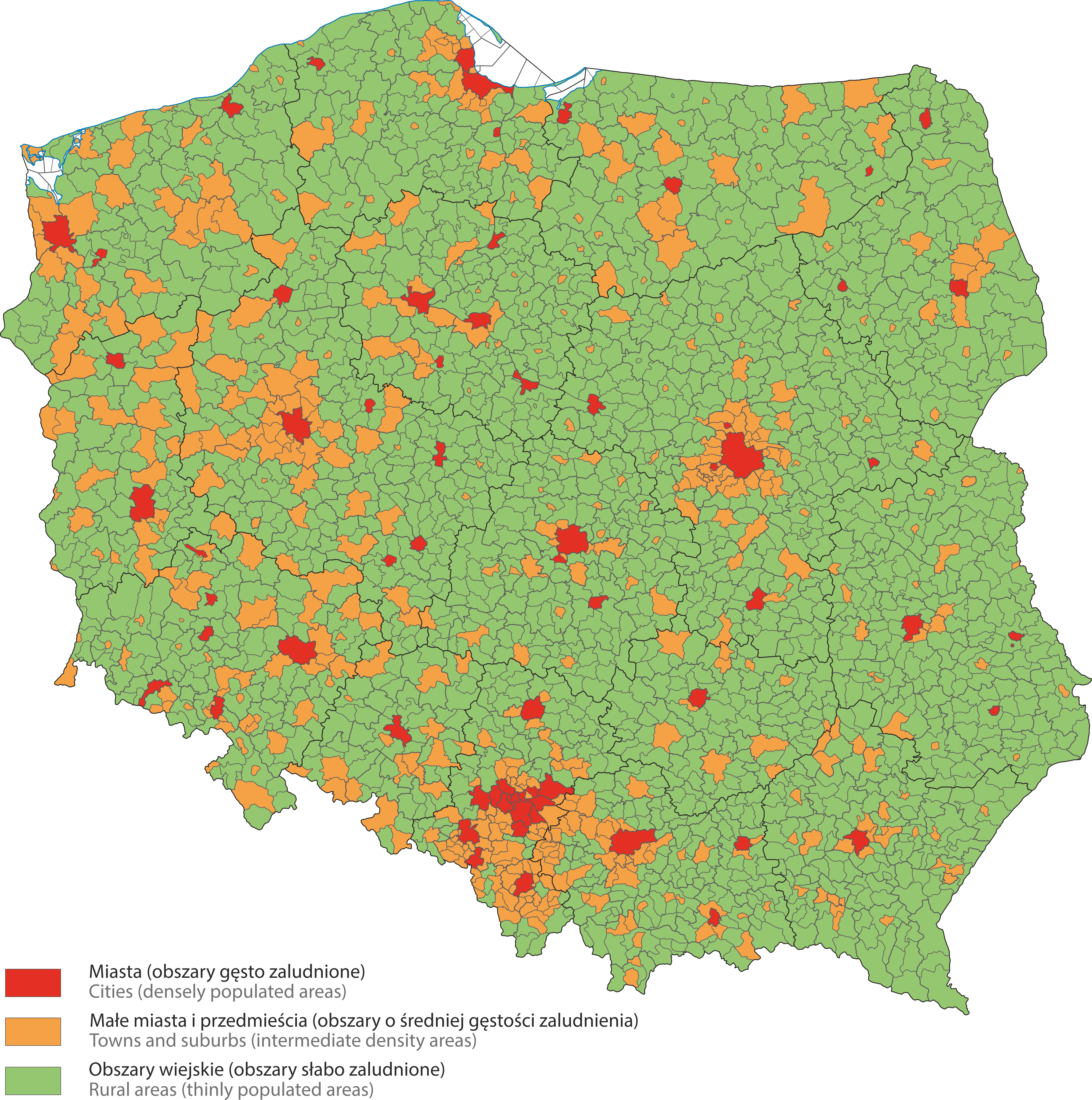
Gminas in Poland according to the degree of urbanisation (DEGURBA) in 2023, determined on the basis of data from the 2021 census.