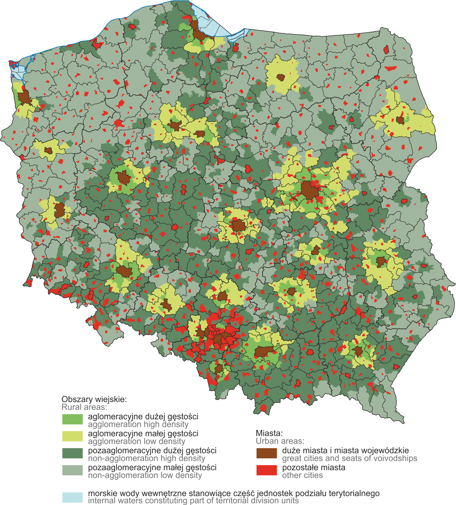
Delimitation of Rural Areas
The Delimitation of Rural Areas for statistical purposes was developed by the Central Statistical Office for the purpose of ensuring a consistent presentation of the results of statistical surveys on rural areas. The use of the Delimitation will enable detailed presentation of data on rural areas, emphasising their diversity.
The Delimitation is developed using the typology of Functional Urban Areas (FUA1 ). The FUA include cities and their commuting zones. The delimitation of rural gminas (rural gminas and rural areas in urban-rural gminas –symbol of the type unit TERYT, 2 and 5 respectively) have been taking into account the impact of large cities
The delimitation includes: level 1. which refers to the location of the area in relation to the FUA of cities of at least 150,000 persons or the FUA of seats of voivodships; level 2. which refers to the value of the population density of rural areas.
|
Level 1 |
Level 2 |
|
Agglomeration areas |
high density |
|
low density |
|
|
Non-agglomeration areas |
high density |
|
low density |
The new delimitation distinguishes the following groups of areas:
- agglomeration — rural areas located within the FUA of seats of voivodships or within the FUA of other cities with at least 150,000 persons:
- agglomeration high density — meet both criteria: they are in agglomeration areas and has population density higher than the average population density for Poland,
- agglomeration low density — they are in agglomeration areas and has population density equal to or lower than the average population density for Poland;
- non-agglomeration — rural areas located outside the FUA of voivodeship cities or outside the FUA of other cities with at least 150,000 persons:
- non-agglomeration high density — they are located outside of the FUA, and have population density higher than 1/3 of the population density for Poland,
- non-agglomeration low density — they are located outside of the FUA, and have population density equal to or lower than 1/3 of the population density for Poland.
The group of seats of voivodships and other cities with more than 150,000 persons includes 25 cities. Average population density in 2025 was 118,9 persons/km2 and the 1/3 threshold of the average population density was assumed at 39,6 persons/km2.
DELIMITATION OF RURAL AREAS IN 2025